 Diagram showing how a beach profile works.
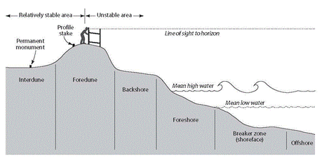
Beach Profiles
"A beach profile is a cross-section taken perpendicular to a given beach contour, the profile may include the face of a dune or seawall, extend over the backshore, across the foreshore, and seaward underwater into the nearshore zone."
- http://www.r3coastal.com/Glossary--Acronyms
How to Make a beach profile:
- You need two or three people to measure the angle of a slope between two points.
- Identify a slope unit between two breaks of slope. Measure this distance.
- Person A stands at the bottom of the slope with the clinometer resting on top of a ranging pole.
- Person B holds a second ranging pole at the top of the slope.
- Person A sights the clinometer at the top of the ranging pole held by B and reads off the slope angle.
- Angles going uphill are recorded as positive (+) angles and downhill as negative (-) ones. Measuring the angle of a slope at regular intervals is more straightforward, but it tends to hide the small variations in slope which can be important on a beach.
- Measuring from break of slope to break of slope means that you have to estimate where the slope angles change. This means that you normally end up taking more slope readings, but the profile that you draw is more accurate.
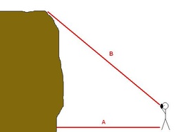 Diagram showing how a cliff survey works.
Cliff surveys
Aims
- To examine physical characteristics and features along a stretch of coastline.
- To identify different rock types and investigate the links between geology and physical features.
- To compare coastlines with different geologies.
- To study evidence of coastal erosion, including sub-aerial weathering, mass movement, basal erosion by the sea, human activity
- To investigate and analyse strategies for protecting against coastal erosion
Equipment
- Plain paper, pencil and rubber for sketch
- Camera
- Geological guides
- Secondary evidence, for example photographs, maps, newspaper cuttings
- Tape measure
- Clinometer
Methodology - Cliff height
- Standing a safe distance from the cliff, measure distance (A) using a tape measure. A distance of around 10 meters may be appropriate, but this depends on the size of the beach
- Use a clinometer towards the top of the cliff to measure angle (B
- The height of the cliff is calculated as follows:
Distance (A) x tan of angle (B) + height of observer
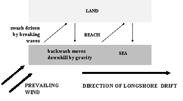 Diagram showing how longshore drift works.
Measuring longshore drift
Aims
- To examine the transport of material along a stretch of coastline
- To compare processes of sediment transport in different locations along the coastline
- To investigate the effect of management techniques on the movement of beach material along the coastline
- To examine the causes and effects of changes to the dominant direction of longshore drift
Observing swash and backwash, and transport of material
Equipment
- Float, for example an orange or cork
- Stopwatch
-Tape measure
Methodology
1. Decide on an appropriate distance to measure longshore drift over, for example 10 metres
2. Lay out tape measure close to water and mark start and finish points
3. Place your float into water in the breakwater zone at the start point
4. Observe and time the object's movement across the pre-set distance
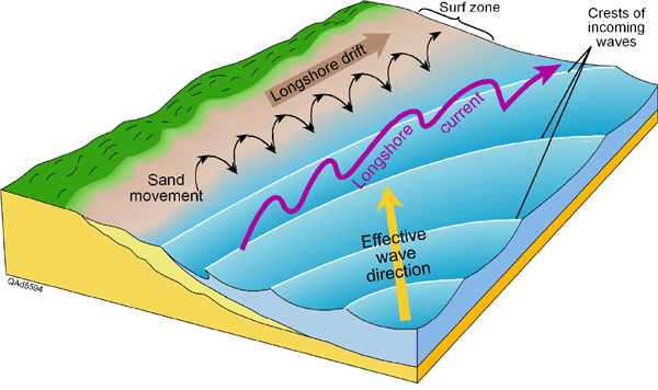
A clear diagram showing what longshore drift is.
